We need your input for Mudgeeraba’s Walking Network Plan The City of Gold Coast is developing a Walking Network Plan (WNP) for Mudgeeraba to create a safer, more accessible, and better‑connected network of walking and riding routes throughout the area. Your feedback will help improve local paths, crossings, and links between key destinations so walking and active travel become easier, safer, and more enjoyable for everyone.
The Mudgeeraba WNP focuses on:
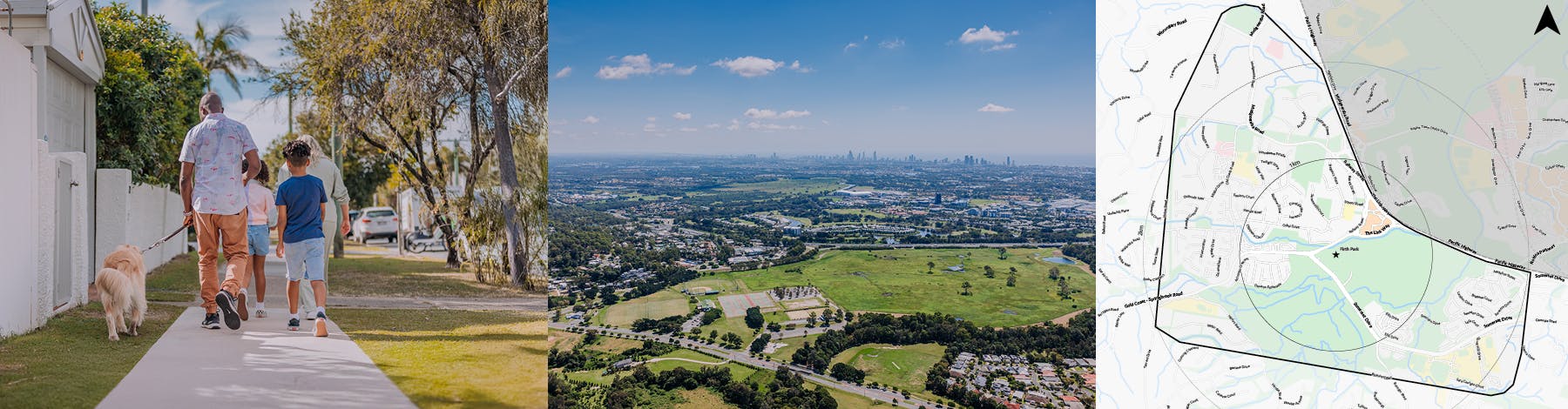
connecting key community and recreation areas in the study area shown in the maps
improving pedestrian safety: Identifying unsafe crossings, areas with high vehicle speeds, and places where safer pedestrian and school‑related routes are needed
enhancing everyday walking and riding: Looking at missing footpaths and shared paths, shaded routes, lighting, accessibility improvements and more comfortable connections throughout the suburb
supporting an active, healthy neighbourhood: Creating routes that encourage walking, jogging, riding, and general outdoor activity, and strengthening links to recreation, shops, parks, schools, and transport.
Once completed, the Mudgeeraba Walking Network Plan study will inform future upgrades to improve safety, accessibility, and connectivity, via a list of projects for inclusion in the Active Transport Infrastructure Program.
We want to hear from you! Your input is vital to ensure the Mudgeeraba WNP reflects the needs of local residents, families, businesses, and visitors.
Tell us about:
your experiences walking, riding, or using mobility devices in Mudgeeraba
areas where paths or crossings are missing
places that feel unsafe or difficult to access
improvements that would make you walk or ride more often
opportunities to better connect local parks, schools, shops, and community spaces.
Have your say today by:
completing the survey (and then accessing the interactive map)
dropping pins on the interactive mapto highlight specific locations that need attention. You can access the interactive map from the bottom of this page or after completing the survey.
Consultation is open until Thursday 5 March 2026.
We need your input for Mudgeeraba’s Walking Network Plan The City of Gold Coast is developing a Walking Network Plan (WNP) for Mudgeeraba to create a safer, more accessible, and better‑connected network of walking and riding routes throughout the area. Your feedback will help improve local paths, crossings, and links between key destinations so walking and active travel become easier, safer, and more enjoyable for everyone.
The Mudgeeraba WNP focuses on:
connecting key community and recreation areas in the study area shown in the maps
improving pedestrian safety: Identifying unsafe crossings, areas with high vehicle speeds, and places where safer pedestrian and school‑related routes are needed
enhancing everyday walking and riding: Looking at missing footpaths and shared paths, shaded routes, lighting, accessibility improvements and more comfortable connections throughout the suburb
supporting an active, healthy neighbourhood: Creating routes that encourage walking, jogging, riding, and general outdoor activity, and strengthening links to recreation, shops, parks, schools, and transport.
Once completed, the Mudgeeraba Walking Network Plan study will inform future upgrades to improve safety, accessibility, and connectivity, via a list of projects for inclusion in the Active Transport Infrastructure Program.
We want to hear from you! Your input is vital to ensure the Mudgeeraba WNP reflects the needs of local residents, families, businesses, and visitors.
Tell us about:
your experiences walking, riding, or using mobility devices in Mudgeeraba
areas where paths or crossings are missing
places that feel unsafe or difficult to access
improvements that would make you walk or ride more often
opportunities to better connect local parks, schools, shops, and community spaces.
Have your say today by:
completing the survey (and then accessing the interactive map)
dropping pins on the interactive mapto highlight specific locations that need attention. You can access the interactive map from the bottom of this page or after completing the survey.
Mudgeeraba Walking Network Plan is currently at this stage
This consultation is open for contributions until 5 March 2026.
Under review | March - April 2026
this is an upcoming stage for Mudgeeraba Walking Network Plan
The project team will review the survey data and report back on key outcomes.
Final report | Mid 2026
this is an upcoming stage for Mudgeeraba Walking Network Plan
The final outcomes of the consultation are documented here. This may include a summary of all contributions collected as well as recommendations for future action.