

New version of City Plan
This new version of City Plan incorporates the Yatala Enterprise Area Industry Amendment, New Road Widening Overlay Amendment, and Minor and Administrative Amendment 12.
Yatala Enterprise Area Industry Amendment
What are the changes?
- Amending the material change of use (MCU) tables of assessment of the High impact industry zone and Future high impact industry precinct to make Low impact industry, and a Warehouse with a GFA under 4000m2, impact assessable in the Yatala/Stapylton industrial area.
- Amending the High impact industry zone code to specify a minimum GFA of 4000m2 for each tenancy within a Warehouse to facilitate large format uses.
- Amending the reconfiguring a lot (ROL) table of assessment to reduce the minimum lot size to 1 hectare for Future high impact industry precinct lots where they are serviced by reticulated water and sewer.
- Introduction of a new table of assessment for the Innovation zone for the Gold Coast screen industry precinct.
-
Amending the Innovation zone code to include the Gold Coast screen industry precinct which nominates alternative:
- setbacks;
- building height;
- landscaping;
- access provisions;
- network infrastructure requirements; and
-
allowance for short term accommodation associated with the screen industry.
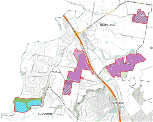
Figure 1 – New zoning in the Yatala/Stapylton industrial area
Why are the changes being made?
The purpose and general effect of the Amendment is to:
- Support existing High impact industry development located on the western side of the M1 to modify and grow over time and also support the delivery of Medium impact industry development within the vicinity of Quinns Hill Road East.
- Support additional High impact industry development on the eastern side of the M1.
- Strengthen and better protect the High impact industry zone by restricting Low impact industry uses and small Warehouses from being established within the High impact industry zone in this area.
- Extend the application of the Industry interface area component of the Industry, community infrastructure and agriculture land interface area overlay to ensure new sensitive uses are designed to protect themselves from the potential impacts of nearby industrial uses.
- Introduce provisions into the City Plan to facilitate screen industry development at 396 Stanmore Road, Yatala.
New Road Widening Overlay Amendment
What are the changes?
The purpose and general effect of this amendment is to introduce a new overlay to the City Plan called the Road Widening Overlay (the overlay). To create the overlay, a range of changes are being made to City Plan The table below summarises these changes:
Part |
Subsection |
Summary of change |
Part 1 – About the City Plan |
1.5 Building work regulated under the City Plan |
Introduce new building assessment provisions. The overlay will provide alternative boundary clearance provisions to the QDC for building works development (instead of those in MP1.1 and 1.2). The changes mean that where the overlay applies to a property, front setbacks for buildings and structures are to be taken from the future front boundary rather than the existing front boundary. |
Part 5 – Tables of Assessment |
Table 5.10.20: Road widening overlay |
Introduce a new table of assessment for the overlay. The table applies the Road widening overlay code to all development (i.e. all MCU, ROL, OPW and BW) that is on a lot affected by a ‘Road widening requirement area’ shown on the Road widening overlay map. No changes are made to levels of assessment. |
Part 8 – Overlay |
8.1 Preliminary 8.2.16 Road widening overlay code |
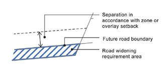
Preliminary updated to include the overlay and renumber other overlays as required. The Road widening overlay code has been created and has two main objectives:
2. Ensure development is resilient to the future road widening |
Part 9 – Development codes |
9.4.13 Transport code |
Change to remove redundant content relating to earlier road widening provisions (PO/AO17 deleted). |
Schedule 2 - Mapping |
SC2.6 Road widening overlay map |
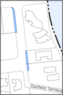
A new overlay map has been created. The map identifies the land required as a ‘Road widening requirement area’ and distinguishes between trunk and non-trunk roads as shown below:
Here is an example of the mapping in Surfers Paradise:
The map directly affects 323 lots across the city. |

Why are the changes being made?
As our city grows there is a need to plan for expanding parts of our transport network to provide improved safety, active and public transport, and network efficiency. To support this process, the overlay identifies land that is needed for future road widening projects undertaken by Council.
The primary purpose of the overlay is to ensure new buildings and structures are not constructed in areas required for future road widening and that they are also set back from future roads.
The Road widening overlay also seeks to ensure new development is designed and located to avoid reliance on areas required for future road widening. This is to ensure development remains functional after the road widening has occurred.
The proposed changes do not affect existing lawfully established uses or current development approvals. The Road widening overlay will only apply to new development.
Minor and Administrative Amendment 12
What are the changes?
The purpose and general effect of this amendment is to:
- Reflect an update to the SPP Mining and extractive resources mapping. These changes only relate to Key Resource Area (KRA) 65 Jacobs Well.
- Include an Editor’s note at the end of s5.3.2(1) to clarify the applicable category of assessment where a proposed use consists of multiple defined use. This change is applicable across the whole of the local government area.
Why are the changes being made?
SPP Mapping alignment
On 14 My 2025 the State updated State Planning Policy mapping layers for the Mining and extractive resources State interest for Jacobs Well KRA 65. The updates are shown in the State Planning Policy Interactive Mapping System and have now been directly incorporated into the City Plan’s Extractive resources overlay map. The changes affect the ‘Resource area / processing areas’ and ‘Separation areas’ at Key Resource Area (KRA) 65 Jacobs Well.
Part 5 Editor’s Note
An Editor’s note has been inserted into section 5.3.2(1) of Part 5 to clarify the intent of the current drafting of City Plan. The note clarifies that where a proposed land use consists of multiple defined land uses, it is intended that the applicable category of assessment is to be determined as the highest category of assessment relevant to those land uses individually.
